Product Spotlight: NexSens iChart Software
0 NexSens iChart is an advanced Windows-based data acquisition software package designed for environmental monitoring applications.
It supports interfacing both locally (direct connect) and remotely (through telemetry) to NexSens iSIC and submersible data loggers. The software simplifies and automates many of the tasks associated with acquiring, processing, analyzing, and publishing environmental data.
iChart has been designed with an open architecture, offering an easy-to-use set of tools to configure and customize monitoring projects. The graphical user interface eliminates the need for learning complicated programming languages to set up and maintain a network of remote sensors.
iChart offers a large device library for integrating data from popular environmental sensors and systems. Users select manufacturer and model numbers from a device index; the built-in device profile simplifies setup and eliminates the need for complex sensor programming. Remotely deployed iSIC and SDL submersible data loggers with radio, phone, cellular, Ethernet, and satellite telemetry provide real-time data access.
iChart includes a unique report generator tool for building customized reports with historical data from all remote sites. Standard reports include time series plots with single or multiple traces, data tables, and statistical summaries generated for specified time periods.
Users have the option to save report templates, eliminating the need to recreate the same report. To further automate the process, reports can be automatically generated and e-mailed to a predefined user list.
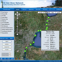
For projects that require real-time data access from multiple locations, iChart can automatically post data to Web-based project datacenters, including the NexSens WQData Web datacenter.
This automated environmental monitoring software is built on open standards and is designed to work with industry-leading sensors and data loggers.
For more details, call Fondriest Environmental at (888) 426.2151, e-mail customercare@fondriest.com, or visit http://www.fondriest.com/products/nexsens_ichart.htm.