Product Spotlight: NexSens WQ Data Web Datacenter
0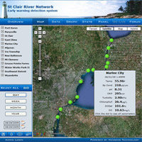 NexSens WQData is a secure online datacenter, providing a Web interface for real-time environmental data. It offers constant access to measurement parameters from remote NexSens data logging and telemetry systems.
Visitors can view dynamic project area maps that are updated with live data. It’s also possible to see project data on virtual instrument displays and to view recent and historical data, time series graphs, statistical summaries, and project-specific information.
The Map View allows users to see real-world project maps with zoom, scroll, and drag capabilities. They can interact with the map by zooming for a detailed look at the project site as well as nearby terrain or adjacent shorelines.
The Data View provides the most recent data, a historical table, and a quick download feature. Time-series graphs can be quickly viewed and customized.
Users can automatically view generated plots for parameters of interest. Additionally, a stats tool can automatically generate statistical summaries including minimum, maximum, number of points, average, and standard deviation.
Project datacenters can be set up as password-protected or open-access sites. An administrator login provides an intuitive interface for setting up the project, modifying data views, and adding relevant project information. A unique site can be created from a library of predefined themes, site descriptions, data filters, graph scales, and other graph attributes.
Also included with WQData is a Web data applet. Simply embed the automatically generated applet HTML code onto a Web page to present visitors with a quick snapshot of project data, while also letting them click through to the complete project datacenter.
To learn more about the NexSens WQData Web Datacenter, call Fondriest Environmental at (888) 426.2151, email customercare@fondriest.com, or visit http://www.fondriest.com/products/wqdata.htm.


