• News
  • Lake Facts
  • About

Lake Scientist

Wetland Restoration — Silver Lake

0
  • by Lake Scientist Staff
  • — March 20, 2009

Project Overview

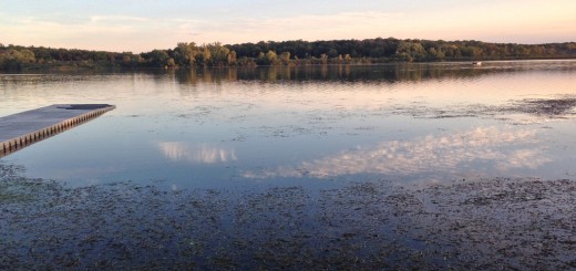
The Silver Lake Wetlands are unique and complex. An ancient glacial kettle lake surrounded by hills of gravel soil deposits has existed since shortly after the Wisconsinan Glacier retreated some 15,000 years ago.

One of Ohio’s best examples of a freshwater fen is located on the northwestern side of the lake. Despite drainage attempts over the last century, the lake and fen maintain their integrity.

To aid in the understanding and preservation of the existing wetlands and fens and the restoration of the degraded marshes and wet meadows, an automated hydrologic monitoring system was installed at Silver Lake.

System Description

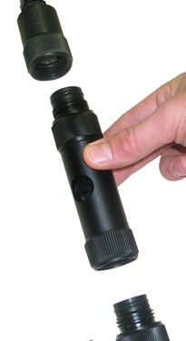
At various locations throughout the wetlands, NexSens radio telemetry, YSI 600 LS multi-parameter sondes with temperature, conductivity, and water level sensors, and RM Young tipping bucket rain gauges were installed.

From each location, data are collected and transmitted via a license free, spread spectrum radio to a nearby farm, where a NexSens radio/modem is connected to a telephone line. On a periodic schedule, a computer calls to the remote project site, collects the data, and posts it to a WQData.com datacenter.

Researchers at Miami County Parks, University of Dayton, Wright State University, and the Ohio EPA all have access to this data via the Internet, aiding in the research, understanding, and preservation of the wetlands.

Share

You may also like...

  • Crowdsourced Secchi Depth Data Reveal Changing Clarity of Midwestern Lakes
  • temperature profiling Product Spotlight: NexSens T-Node Water Temperature Strings
  • White Bear Lake Proposed study would investigate record-low water level of White Bear Lake
  • Figure 1: The Great Lakes in the U.S. and Canada are well-known examples of lakes produced by multiple glaciations and deepened by glacial scouring. Findings released from five-year USGS study on water availability in the Great Lakes Basin

Leave a Reply Cancel reply

Your email address will not be published. Required fields are marked *

Time limit is exhausted. Please reload CAPTCHA.

BUY AT FONDRIEST.COM
New NexSens XB200 Data Buoy
  • Recent Posts

    • No Red Herrings: Data Driving the Largest Salt Marsh Restoration in the NE USAJune 16, 2025
    • Storm surge from Hurricane Irene in Greenwich, Connecticut.Research Brief: Evaluating a Novel Storm Surge Prediction Model on Lake OntarioJune 16, 2025
    • Carbon and Nutrient Monitoring in the Great Lakes Using Satellite ObservationsJune 11, 2025
    • Craig Hill places the Spotter Buoy into Lake Superior near Park Point Beach in Duluth, MN.Research Brief: Evaluating Wave Energy Availability in the Great Lakes and Blue Economy Opportunities June 9, 2025
    • Restoring North Texas Streams to Historical FlowsJune 9, 2025
  • Popular Tags

    Great Lakes research summary research research brief pollution Lake Erie Algae invasive species Product Spotlight lake research climate change lake science runoff nutrient-loading Lake Michigan dissolved oxygen international temperature Ohio eutrophication EPA toxic waters ice phosphorus algal blooms

©2025 Fondriest Environmental Inc. | Questions? Call 888.426.2151 or email customercare@fondriest.com