• News
  • Lake Facts
  • About

Lake Scientist

Proposed study would investigate record-low water level of White Bear Lake

0
  • by Greg Loughnane
  • — February 4, 2011

White Bear Lake

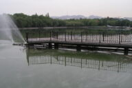
Minnesota’s White Bear Lake has been achieving record-low water levels for the past several years, but researchers aren’t yet sure why. A proposed federal study would aim to further understand the problem by examining the sources of water entering the lake.

The $200,000 study is planned to begin this spring and continue through the summer. In that time, according to hydrologist Perry Jones of the U.S. Geological Survey, scientists intend to identify general areas where groundwater is entering. He said he hopes the study would gather data on where and how much water is coming into the lake. This information would help researchers quantify the importance of inflow with respect to the overall water level.

If the study does receive funding, preliminary results will likely be available by next February. Funding will have to be a joint effort between the USGS, which has agreed to pitch in half of the cost, and local partners that must be able to cover the rest.

“This lake belongs to everyone. Everyone has a stake in this,” said Mike Crary, head of the White Bear Lake Homeowners Association. Crary has also mentioned how low water levels are driving home values down, leading to decreased city tax revenue.

A work session is planned for early this month, during which the USGS study will be pitched to stakeholders in the area. The study, Jones said, “will provide [stakeholders] more information so they can better understand and influence some of the impacts on the watershed and how they affect water levels.”

White Bear Lake is shrinking — $200,000 study would examine why [Pioneer Press] White Bear Lake levels to get new investigation [White Bear Press]

Image Credit: NASA

Share

You may also like...

  • Increased water withdrawal limits in works for Ohio
  • Satellite tracking of loons will assist avian botulism study
  • A new carbon model indicates that in larger U.S. rivers, such as the Mississippi River, photosynthesis by algae is the one of most significant sources of organic carbon. USGS study develops new surface water carbon model
  • OTT RLS Radar Level Sensor Product Spotlight: OTT RLS Radar Water Level Sensor

Leave a Reply Cancel reply

Your email address will not be published. Required fields are marked *

Time limit is exhausted. Please reload CAPTCHA.

FishSens SondeCAM HD
  • Recent Posts

    • Sampling on Lake St. Clair, July 29, 2013.Research Brief: Contaminants in a Great Lakes Urban-Dominant WatershedJune 2, 2023
    • Sea LampreyResearch Brief: Incorporating the Two-Eyed Seeing Approach into Sea Lamprey ManagementMay 26, 2023
    • USCGC Mackinaw Entering Duluth HarborResearch Brief: Full-Year Zooplankton Dynamics Along a Nearshore Depth GradientMay 19, 2023
    • Image of Lake 239 at IISD Experimental Lakes Area from aboveResearch Brief: Using Sediment DNA to Determine Long-Term Cyanobacterial DynamicsMay 12, 2023
    • Crystal Clear Problems: Impacts of Water Transparency in Aquatic EcosystemsMay 1, 2023
  • Popular Tags

    Great Lakes research pollution Lake Erie research summary Product Spotlight invasive species Algae international runoff Lake Michigan Ohio dissolved oxygen nutrient-loading EPA temperature eutrophication toxic waters climate change USGS ice phosphorus Asian Carp Michigan restoration

©2023 Fondriest Environmental Inc. | Questions? Call 888.426.2151 or email customercare@fondriest.com