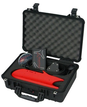
Product Spotlight: StarFish Seabed Imaging System
0 The StarFish seabed imaging system is an affordable, high performance, side-scan sonar that produces near photographic-quality images of the sea floor. It is ideal for surveying lake bottoms for research purposes, dive sites, submerged structures, or shipwrecks.
StarFish is the smallest side-scan towfish on the market, measuring less than 15″ long, and it is light enough to be easily deployed and operated by a single person from even small vessels. Instead of the usual side scan torpedo-shape, StarFish uses advanced hydrodynamic principles to stabilize the sonar using three fins across the entire sonar body, which combine to force the flow of water over the StarFish and keep it steady. Each side fin is angled 30 degrees down from horizontal providing a stable, rigid platform to house the sonar transducers.
Utilizing Tritech’s Digital Sonar Chirp Technology, developed from the professional underwater survey industry, StarFish makes hi-tech seabed imaging accessible to anyone. Chirp Technology offers far better image and range resolution compared to conventional fixed-frequency side-scan sonars.
The device can connect to any Windows-based computer via a plug-and-play USB connection, and the included software is designed to be easy enough for side-scan sonar novices but advanced enough for experienced users.
The StarFish ships ready to go with software, 20 meter tether, topside processing unit, and towfish included. Simply load the ScanLine software on your Windows-based computer, plug the topside processing unit to a computer’s USB port, connect the tether, supply 12 VDC, and begin scanning the seabed.
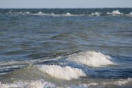
StarFish also offers a hull-mounted side-scan sonar that can attach to the hull or stern of most boats to capture real-time digital images of the seafloor as the boat travels. Hull-mounted systems produce their best sonar images on calm waters where there is little wave motion and surface chop affecting the boat. A flexible mounting bracket makes it easier to fix the sonar to a suitable location on a vessel’s hull.
For more details, call Fondriest Environmental at (888) 426.2151, e-mail customercare@fondriest.com, or visit http://www.fondriest.com/products/side_scan_sonar.htm.