Research Brief: ASV Optimization in Lakes Prine to Harmful Algal Blooms
0Autonomous water quality sampling strategies can help researchers gather high-resolution spatial data in a body of water. Such methods include the use of drones and other autonomous surface vehicles (ASVs) equipped with water quality measurement equipment set to collect data consistently on the ASV.
In order for these types of monitoring systems to work, the equipment must consistently record data points, and the planned speed and route (including pauses) must give sensors time to measure the various parameters.
A 2024 study published in the Journal of South Carolina Water Resources sought to determine the best speed and duration of loiter required for accurate data collection on an ASV.1
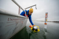
ASV design used in this study. (Venkatachari et al., 2024)
Methods
The ASV in this study was a motorized kayak designed to run autonomously and equipped with a YSI EXO2 sonde.1 The sonde measured depth, temperature, conductivity, dissolved oxygen, pH, turbidity, and phycocyanin and was deployed horizontally on a rigid mount at 0.5 m below the surface to reduce the influence of turbulence.
The ASV was programmed to travel a 483 m transect in Lake Wateree, South Carolina, a hydroelectric reservoir that experiences extensive blooms of the benthic cyanobacteria Microseira (Lyngbya) wollei and Phormium sp. Due to a combination of point and non-point source nutrient loading.1
Three different speeds were tested (0.9 m/s, 1.8 m/s, and 2.7 m/s), as well as two loiter times (20 and 40 seconds) based on the observed response times of the sensors.
Data from the ASV were compared to a stationary YSI EXO2 sonde equipped with the same sensing instrumentation deployed at a point mid-way through the ASV’s designed path to assess the data accuracy obtained at different speeds and loiter periods.
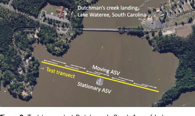
Test transect at Dutchman’s Creek Arm of Lake Wateree, SC. (Venkatachari et al., 2024)
Results
Results of the study revealed that turbidity, phycocyanin, and dissolved oxygen measurements were the most affected by motion, especially at the highest speed of 2.7 m/s.
In particular, dissolved oxygen was higher at the stationary sonde, likely due to the moving sonde measuring mixed water due to the movement. Turbidity and phycocyanin are expected to have been impacted for a similar reason.
For ASV speed, 1.8 m/s was found to be the most reliable for obtaining data in the lake based on the sensors used in this study. The study also concludes that frequent loiters of at least 20 seconds are necessary to obtain more accurate data, as discrepancies between the stationary and moving sonde were alleviated during pauses.
Ultimately, the study demonstrates the potential of ASVs in water quality monitoring applications in lake environments. Future research will further refine ASV use on Lake Wateree and ideally lead to high spatial and temporal resolution data.
Source
- Venkatachari, A., Bourbonnais, A., Salman, I., Rekleitis, I., Quattrini Li, A., Cottingham, K., Ewing, H., Bruesewitz, D., Arsenault, E., & Shingai, Q.K. (2024). Use of an Autonomous Surface Vehicle to Collect High Spatial Resolution Water Quality Data at Lake Wateree, SC. Journal of South Carolina Water Resources.