• News
  • Lake Facts
  • About

Lake Scientist

Exposed Salts Spell High Albedo For Russia’s Lake Elton

0
  • by Daniel Kelly
  • — December 9, 2014

Russia’s Lake Elton is one of the largest and saltiest inland lakes in Europe. But it is probably better known for its reflective properties, according to a release from NASA’s Earth Observatory.

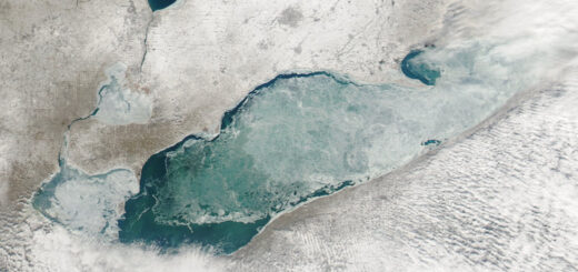
This reflectance is called albedo, essentially the proportion of sunlight an object receives related to the amount of sunlight it reflects back. And Lake Elton has an almost unreal level of albedo, as seen in this satellite photo from August 2014:

lake-elton-aug-2014

Lake Elton as seen from space in August 2014. (Credit: NASA Earth Observatory, Landsat 8)

A team of researchers looked into Lake Elton’s reflectance in 2012 by analyzing ten years of daily satellite images of the lake. When it is at its shallowest point of the year, typically in late summer and fall, the team found that’s when Elton has its highest albedo.

A few factors appear to contribute to the lake’s reflectance at that annual time: rain storms are less common during early fall, which leaves salt minerals exposed; and reduced rains spell a decrease for sediment levels.

Elton-lake-salt-crusts

Salt pan on Lake Elton. (Credit: Wikimedia Commons User Vissarion via Public Domain)

It’s useful to note that albedo is measured on a scale of 0 to 1, with a score closer to 0 indicating less albedo. In 2005, the study’s authors noted that Lake Elton’s albedo changed dramatically – from 0.14 in 2004 to 0.40 in 2009 – most likely due to the installation of new dams around the lake and sediment reductions they brought.

Share

You may also like...

  • lake taupo Lake Taupo is New Zealand’s Largest
  • MODIS image of Lake Erie ice cover. February 6, 2009. Such physical climate-related shifts are easily captured by satellite imagery. Research Brief: Measuring Climate-Related Shifts in Lake Ecosystems
  • great salt lake Living Rocks In Great Salt Lake
  • lake ladoga In Northwest Russia, Lake Ladoga is Europe’s Largest

Leave a Reply Cancel reply

Your email address will not be published. Required fields are marked *

Time limit is exhausted. Please reload CAPTCHA.

BUY AT FONDRIEST.COM
New NexSens XB200 Data Buoy
  • Recent Posts

    • Spring 2025 Environmental Monitor Available NowMay 7, 2025
    • Research Brief: CyanoHABs Forecasting in Satellite Monitored LakesMay 5, 2025
    • Supplying Seattle’s Drinking Water: Using Data Buoys to Monitor the Cedar River Municipal WatershedApril 30, 2025
    • A high-mountain lake in Manti-La Sal National Forest.Research Brief: Threats to High-Mountain Lakes in the AlpsApril 28, 2025
    • MODIS image of Lake Erie ice cover. February 6, 2009. Such physical climate-related shifts are easily captured by satellite imagery.Research Brief: Measuring Climate-Related Shifts in Lake EcosystemsApril 21, 2025
  • Popular Tags

    Great Lakes research summary research pollution research brief Lake Erie invasive species Algae Product Spotlight climate change lake research lake science runoff nutrient-loading international Lake Michigan dissolved oxygen temperature Ohio eutrophication EPA toxic waters ice USGS phosphorus

©2025 Fondriest Environmental Inc. | Questions? Call 888.426.2151 or email customercare@fondriest.com